The Oregon Back Country Discovery Route is a trail that runs North/South across Oregon - From the California border to the Washington border. The trail is suitable for 4WD vehicles.
The following photos were taken on a run of the of the trail California to Stauffer, May 25 to 28 2001. A trip report appears at the bottom of this page.
We have collected GPS logs for the route. Over the winter all the GPS logs, maps, selected photos and such will be assembled and made available to others wishing to explore this wonderful trail across Oregon.
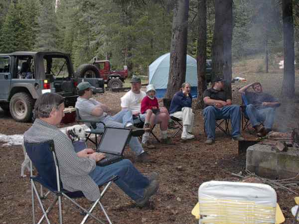
Our camp Friday evening after the drive South to begin the trip. We are actually just inside California at this spot. If you look carefully you will spot a little snow near the upper right and the left center just in front of the Jeep. It was still pretty cold at night here. (I used the laptop to download photos and the GPS track - not for work during the trip!)
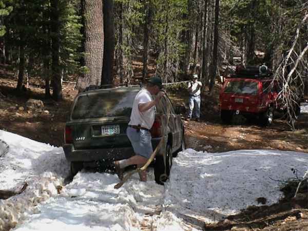
Bill got stuck here. A pull from the rear (no tow point on the front) let him get another run at the snow and plow through it on the second try. (You would think that an "off road" vehicle costing over $20K would come with good tow points front and rear as standard equipment. But then again you might think they would come standard with good strong steel bumpers and a which.) We encountered this snow about an hour out of camp the first day and it caused a little concern at first. We were fortunate that this was a "low snow" year. This first section of the trail could have been hard traveling in a year with a lot of snow. The elevation quickly dropped so we crossed only a few small patches of snow and then had clear sailing.
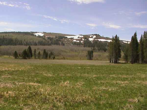
Just after the snow we were at a lower elevation passing by some beautiful meadows. The patches of snow on the hills across the meadows looked spectacular - the photo just doesn't capture the beauty of the area.
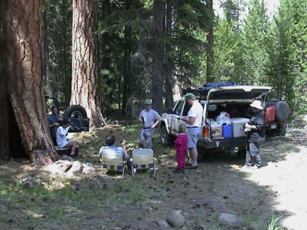
Lunch stop day one. Lunch among the big trees, it doesn't get much better than this.
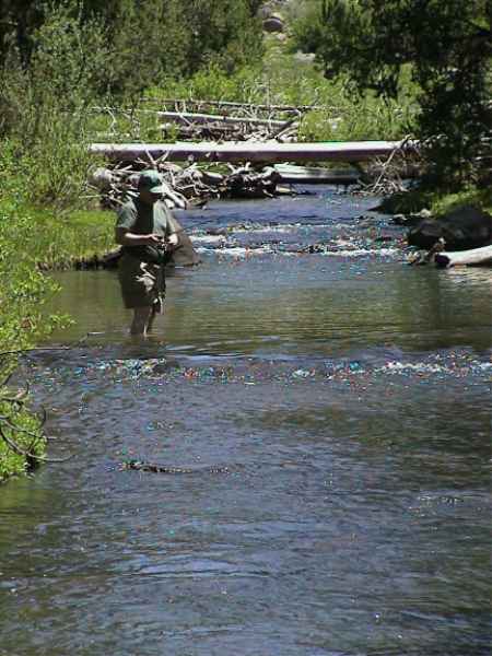
This was our lunch stop day two. Maybe lunch among the big trees with a little fishing thrown in is even better. After catching a few fish the night before Gil tries his luck in another stream. This place would make one fantastic camping spot. (I was careful to record the GPS coordinates for this place.)
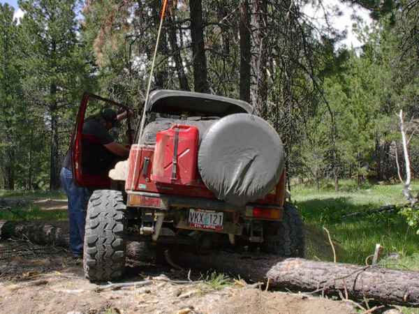
Before dragging a log out of the way maybe you should try driving over it. At this point the winch cable is coming off the spool. With a little help from the winch Eric was off the log. We then used a tow strap to pull the log from the trail so the rest of the group could drive on by.
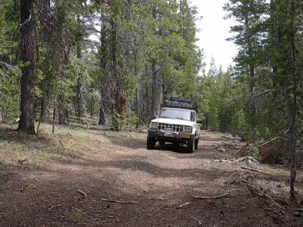
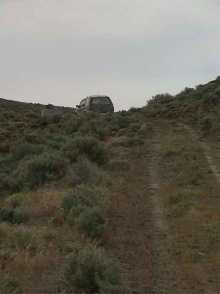
Here is my Cherokee on a typical section of the Southern trail.
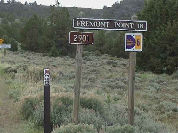
On the Southern section they kindly marked the trail with nice OBCDR signs along the way. This makes the trail easier to follow and gives nice reassurance that you are still on the route. Let's hope that eventually the entire route can be marked and publicized. Once the signs end you really need to have the lead vehicle running a GPS and laptop with a pre-marked route.
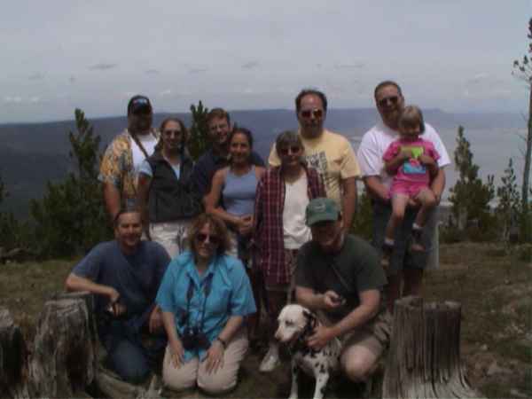
Here is the group at a high point with Summer Lake thousands of feet below.
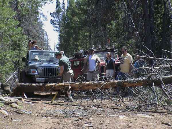
As the first travelers on this section of the route this year we spent quite a bit of time pulling trees off the road. Usually a tow strap (and vehicle with a solid mounting point) will clear the tree. Most of the fallen trees were quite rotten and easily moved but bringing a bow saw is a good idea. There were one or two trees that we cut about a third of the way to make it easier to break them and drag off in a couple sections. This particular section of trail presented us with a downed tree every thousand feet or so on the trail. We probably pulled better than a half dozen trees from this section.
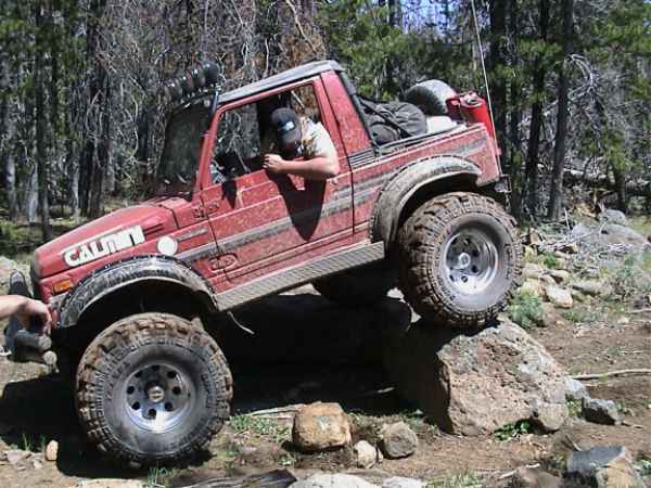
There was plenty of space in the trial to go around this rock but Eric wanted to take advantaged of the clearance and big tires on the Samurai.
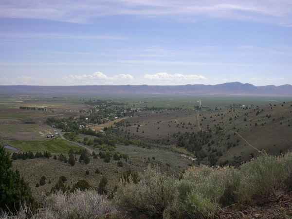
Somewhere in the general vicinity of Paisley. We had many wonderful vantage points of view the landscape.
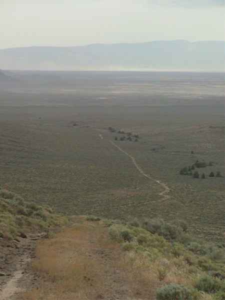
Looking back on the trail day two as we head farther North, still a few hours away from Christmas Valley.
And this is the road looking ahead on the trail. We spent several hours on a road much like this without ever coming across another vehicle. Travel in a group. Alone, with a broken rig, you could sit for a long time before someone happened upon you.
Day three, North of Christmas valley and South of Stauffer. There are a few active cattle raising operations out here as the signs of life we saw were maintained watering tanks for the cattle. But again we spent several hours traveling the dry roads of the area and never saw another car.
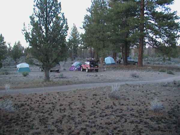
Our camp day two in Lost Forest perhaps 30 miles from Christmas Valley.
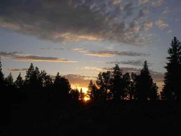
Sunset, in camp day two.
Here is a trip report for the Southern section of the trail. This was written by Gil Meacham, the "trail boss" for the trip.
Several years ago, recreation departments from Oregon, California, and Washington put together a plan for a Backcountry Discovery Route that would encourage people to experience primitive camping while traveling along backcountry roads extending from Mexico to Canada. The plan included many of the most interesting sites in out of the way places. Then they found directions to connect all these places by dirt, gravel, cow paths, and as little asphalt as possible. The route avoids all the urban areas that stretch along I-5 corridor.
The Oregon section was dedicated in 1999. It was the first (and to date the only) completed section. The routes are along mapped and recognized roads. A lot of the roads are seasonal, and not maintained in the winter. Some of the route is in snow country, and usually does not open up until late summer on a big snow year. This year was good for an early start, because of the low snowfall.
Last year, 3 wilderness protection groups in Oregon sued the Oregon Parks Department for not doing environmental impact statements before creating the route. This is somewhat ludicrous, because the route is merely a mapping and signing project. The roads already existed for many years. The wilderness groups are just using any tactic they can to lock up forests from anyone but able bodied hikers. Anyway, the signing was completed on the section from California to just south of Christmas Valley. The rest of the route is mapped, but not signed. Because of the lack of signs, it is necessary to use a book of topo maps to navigate the trail. To make decent time, you really need a GPS and a laptop is really handy for tracking to the topo maps.
When I first heard about the trail it was the time of the dedication. I decided someday I would travel the trail from one end to the other. This last year, I decided it was time. I sold my large Ford diesel pickup and downsized to a 2000 Cherokee. Then I fitted the Cherokee with a lift, 31 inch AT tires, roof rack, heavy duty bumper, driving lights, GPS, laptop, CB and ham radios. I posted an invite on the Oregon Bushhackers mailing list, and about a dozen other people said they would like to join me. The expedition took place May 25th-28th, 2001. Our goal was to travel and document approximately 1/3 of the route running north from Cave Lake, California to where the route crosses Highway 20 east of Bend.
On Friday, the 25th, I left my home in North Plains, and rendezvoused with Dale and Mary Jo Mosby in their similarly equipped 2000 Cherokee at the freeway on-ramp. We rendezvoused with Ed and Pat Bodner in their Explorer at the I-5 rest stop in Champoeg. We caravanned to Tangent, and there we met Jason Hutchison and Jen in his 98TJ Wrangler and Bill Lewey in his 96 (?) Grand Cherokee. After about an hour delay, we were joined by Eric "Evil Empire" Bewley and Sarah in his monster Samurai with the 35 inch swampers and full width Wagoner axles. We caravanned to the Cave Lake campground.
When we arrived at the campground, we received two surprises. First, there was quite a bit of snow still on the ground. Second, fortunately there was nobody in the campground but us on the Friday before Memorial Day weekend! Luckily, there were several tent sites that were on dry ground, so we set up camp and had a nice fire and went to bed. The temperature that night dropped close to 30 degrees. It was at least a 2 dog night. Unfortunately, I only had one along with me, and his fur was so short he was colder than I was. I had to wrap him up in his own sleeping bag, and let him snuggle close to me, but we both shivered most the night.
Saturday morning we enjoyed a late breakfast, and a few other folks wandered into camp. We devised a method of communicating directions between vehicles on the radios so we could allow enough separation to not have to eat each other's dust. I would follow the GPS waypoints, then call out the turns on my radio, along with the mileage. The person behind me would repeat the direction and the mileage, and the person behind would do the same, and so on. We used this method for the rest of the trip, and it worked great except for one time when I let another (not mentioning any names, Monkey Boy!) vehicle lead. Big mistake!
Shortly after we left camp, we came across the next big surprise. There were large snow drifts across the road, and there were two pickups stuck in the snow! Another couple in an old bronco came by and the driver pulled one of the trucks out of the snow. Actually, the truck wasn't really stuck, because the winch never tightened the line before the truck leaped rearward out of the snow bank. By the time the Bronco had moved into position to pull out the second truck, it had already pulled out of the snow and turned around to drive back out.
The realization hit me that we had driven well over 350 miles to get to the start of this route, and now we may have to relinquish our goal to the Gods of snow! We pondered the situation for a few seconds, then said "Nah. we can get through this!" We put the highest clearance vehicle (the Samurai with 35 inch tires) in front, followed by the Wrangler with 33 inch tires, then me with 31 inch tires, and so on until the lowest clearance vehicle. Using this method, we could grade off a little of the snow bank with the passing of each vehicle. It soon was evident our plan was a success, as it was really fun driving over the first few snow banks.
On about the fifth snow bank, Bill's Grand Cherokee lost momentum and sunk to the frame. Ed's Explorer behind pulled him back out, and then he hit the bank with much more momentum. Success! The start of the route is near 8,000 feet. It descends to less then 6,000 feet shortly after the start, so we didn't see any snow on the road after about the first mile. Other than a little mud and some rough rocky sections, we didn't use 4 wheel drive for the rest of the trip.
The scenery was spectacular. All the wildflowers are in bloom, and the colors of the vivid flowers against the rich spring grass in the meadows was intense. We were blessed with clear blue skies and warm sunny days for almost the entire trip. The majority of the trip was at less than 10 miles per hour. We traveled much faster on some of the graded gravel and asphalt sections, but we were averaging about 15 mph.
We lost a few hours on Saturday afternoon when Eric and Jason got out of radio range and missed a turn. We made contact with them long enough to ask them to wait for us to run the correct section and they could rejoin us at a rendezvous point. Unfortunately, the section we ran was not cleared. We had to pull a couple of fallen trees off the road and it took a lot longer than we estimated. Bill had a bit of a casualty when a tree snake reached out and ripped the front bumper off the GC. While we were busy bungeeing the bejesus out of Bill's front fender, Eric and Jason decided we must have left them for dead, so they went on into Paisley, the closest town. We looked for them for over an hour, and about the time we gave up we met them coming up the canyon from Paisley. We continued on the route until an hour or so before dark, and camped next to a beautiful little river that runs into Paisley. There were a few thunderstorms with a great light show and a short period of light rain that night.
The next morning I awoke with the sun and spent an hour of solitude fishing along the river. The fishing was excellent and I caught 15 small (8 to 10") trout. I released them to grow up for my next visit. I had a great French toast breakfast (compliments of Mary Jo), and then packed my camp. Since some of the late risers were still eating and packing, I returned to the stream and caught another couple of fish. The last fish was a nice one(13") but I opted to leave him to grow more, also.
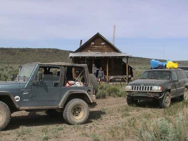
We drove into Paisley to fill up with fuel, but the only gas station in town was closed on Sundays. I went into the mercantile, and the nice lady behind the counter called to a trading post 6 miles up the road and made sure the gent was open before sending us there for fuel. The 12 mile round trip was worth the drive, as the trading post was a real treat. The yard was filled with old wrecks and memorabilia from many eras of the settling of the west. Inside, there were old antique guns, one of the first electric sewing machines, a stone mortar and pestle, and many more relics. Along side the building was an old hand made tin box camper. The proprietor saw us eyeing it and said "when I was a very young boy, my parents drove out here with that camper on a 1932 International Harvester truck." Probably one of the first motor homes in existence. We also noticed the side of the trading post was covered with aluminum siding that looked like printing web plates. The owner straightened us out on that, saying that the plates were actually the uncut tops of beer cans. They originally had Olympia brand screened on them, but it had worn off many years ago. When the stamped aluminum beer cans came into use, the tin tops were obsolete so they sold pallets of them for 10 dollars. The entire roof and siding of the building probably only cost 10 dollars!
We rejoined the route where we left it the day before. This time, we kept the other vehicles with ham radios in the rear, and I led with the GPS and my ham radio to maintain communication with the rear. We kept the flock together, and all went very well. Dale (our official photographer) was in the rear, so he could stop and take pictures of the scenery and flowers while we forged ahead. He would catch up to us between shots and we kept in communication with the ham radio all the while.
We were treated to spectacular views on the Fremont ridge, and more of the beautiful meadows and forest. I pulled into a nice campground next to a river for our lunch stop, and did a little fishing while the others visited, ate lunch, and hiked the river trail. This was one of the prettiest campsites I have seen for some time, and no one was in it on Memorial Day weekend!
We enjoyed another spectacular view after driving up on top of Winter Ridge to the lookout station. There is an old cabin at the base of the station that you can rent. It is perched right on the rim overlooking Summer Lake several thousand feet below. Summer Lake is on a huge alkali flat and several huge dust storms swirled across the flats. We pushed on down off the ridge, hoping to be able to camp in warmer climate at lower elevation.
On the way off the ridge, we came across a section of trail that obviously had not been traveled yet this year. There were several dead falls across the road, and we had to tow them off the road with Jason's Wrangler and a strap to make our way. After finally reaching the valley floor, we elected to continue on the route to through Christmas Valley. We found the going very slow, as the sandy road was rocky in spots and required a slower passage than the smoother roads up in the forest. After a few hours of bouncy dusty driving, we arrived at Christmas Valley and filled our tanks. We continued through the Sand Dunes area and then set up camp off a side road in the Lost Forest.
The Lost Forest is a natural research area, because the area is biologically unique. There is a large stand of Ponderosa trees there, but they are separated by 50 miles from the nearest other stand of Ponderosas. Most Ponderosa growths depend on about twice the annual rainfall of the Lost Forest. Because of the unique moisture holding capability of the sandy soil of the Lost Forest, the trees thrive.
After a chilly night, we awoke to another beautiful sunny morning. There was a slight breeze and the temperature was a little cool. We elected to pull off the route by Stauffer and head for Highway 20 from there. This was several miles short of our goal, but we didn't want to push too hard and end up getting home late and tired. The choice to go by Stauffer was a good one, as there was the remnants of a small ghost town, lots of obsidian chips, and a very interesting rock paved well and matching watering tank. There was also a filled in mine, and quite a few relics strewn about. After pulling onto Highway 20 about 60 miles to the east of Bend we determined the trip was a great success. We had traversed over 200 miles of backcountry roads in Southeast Oregon in 2 1/2 days of leisurely driving.
We had seen amazing natural sites, and experienced a little of the rich culture of the area. It left the desire to return soon and experience the rest of the route's offerings. We are planning on doing a 5 day excursion the week of July 4th. We will leave Portland area the morning of the 4th of July and drive to the spot where we left the route near Stauffer. We will plan on getting back to Portland area the late afternoon of Sunday, July 8th. Camping is primitive, and the road will be dusty. We would encourage you to get a ham license and radio to improve the communications, but it is not required. A GPS is a good idea, so you can tell how lost you are at all times!
Bwana Gil