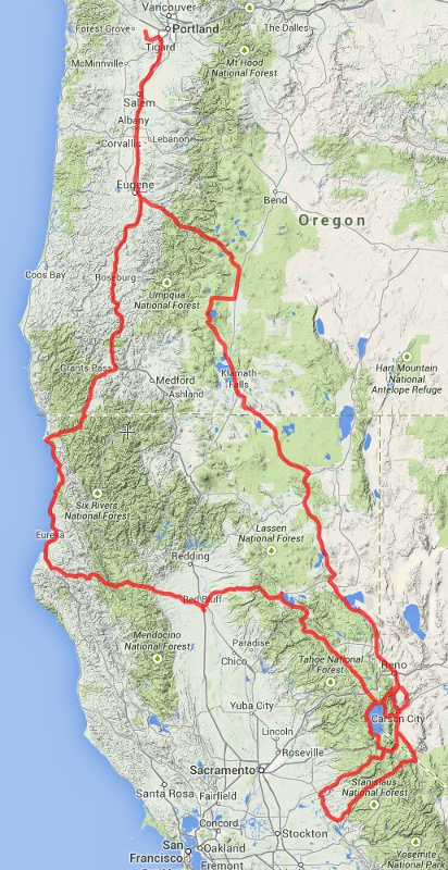
2014 Motorcycle Trip - Oregon, Nevada, California
|
Trip
Report Summary
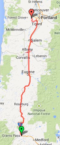
I made an eight day motorcycle trip July 15 through July 22,
2014. Seven of the days were riding with one non-riding
activity day. The trip covered 1943 miles in Oregon, Nevada,
and California. That works out to 277 miles on average each
riding day. I rode two days from the Portland, Oregon to
Carson City, Nevada making a swing by Crater Lake on the way
down. A couple days were spent exploring the beautiful roads
in the area followed by a 3 day ride back to Portland. The
ride back had a run to the California coast allowing me to
ride Highway 36 in California, known for the sign advising
140 miles of curves ahead. |
Ride
Days
Tuesday, July 15
- Portland, Oregon to Klamath Falls, Oregon. 332 miles
Wednesday, July 16
- Klamath Falls, Oregon to Carson City, Nevada. 307
miles
Friday, July 18
- Highway 88 and 4 loop in California. 266 miles
Saturday, July 19
- Lake Tahoe loop and Virginia City. 155 miles
Sunday, July 20 - Carson
City, Nevada to Red Bluff, California. 269 miles
Monday, July 21
- Red Bluff, California to Grants Pass, Oregon via CA
coast. 343 miles
Tuesday, July 22
- Grants Pass, Oregon to Portland, Oregon. 271 miles |
|
|
Tuesday, July 15

|
I
started the trip in Hillsboro, Oregon, a suburb a little to the west
of Portland. I took I-5 south to Eugene then got off the interstate
heading southeast on Highway 58. This took me through the town of
Oakridge where I had a lunch stop and then by Odell Lake. This route
had me traveling through some nice country and much nicer riding
than continuing south on the freeway.
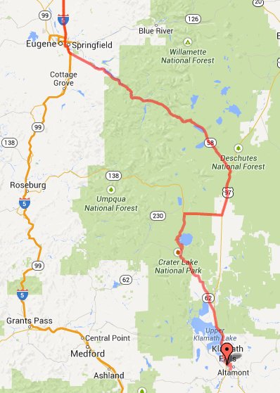
I connected with Highway 97 and had a short ride south before
heading east on 138 taking me to Crater Lake National Park. I rode
Rim Drive on the west side of the lake and then continued south
hitting Highway 62, Crater Lake Highway.
The temperature was hot - really hot. Not bad as long as I kept
moving but unfortunately I encountered two spots with road
construction. The first was up high near the lake with only a brief
stop for traffic and fortunately I was able to stop in some shade.
But the next traffic stop was lower with a 30 minute wait in the hot
sun. There were many miles of fresh gravel on a very long chip seal
stretch. Traffic had to wait for a pilot car to show up and take
accumulated traffic through - for no good reason that I could see as
no work was taking place on the road just some work on a side road.
Once past that the rest of 62 was a great ride back to the
connection with 97 though even with some moving air once again it
was hard to recover from the intense baking under the sun during the
construction delay.
I continued south on 97 into Klamath falls. I did not have a room
booked in advance and found the first hotel full. I got a
recommendation for another place and found a room for the night -
fortunately within walking distance of a dinner spot. |
|
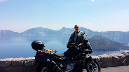
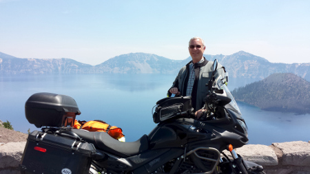
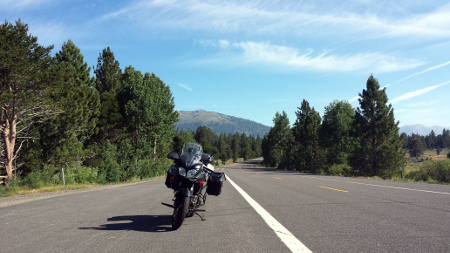
This
shows the second part of the day's ride. I was wearing full gear
well suited to the cooler temperatures of the Oregon coast. Even
though it was hot the 7000 foot elevation of the Crater Lake rim
road made things reasonably comfortable until I got lower and hit
road construction. |
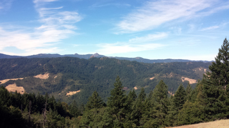
Some photos from Tuesday's ride. Click on a photo to open a larger image.
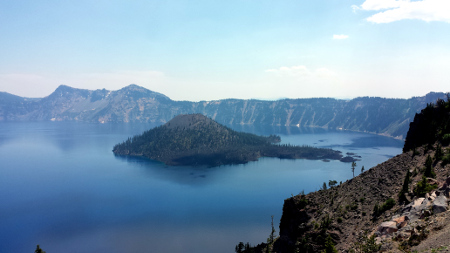
This is the west side of Crater Lake. Wizard Island easily seen under the
clear sky this day.

|
I
got a reasonably early start out of Klamath Falls heading south on
Highway 39. That jogs east on 50 and then south on 139 into California.
The weather was perfect and so was the road - two lanes through
beautiful scenery and no traffic.
Highway 199 links up with 299 and for a while they merge into one
road with two designations. Eventually they split with 299 heading
west. I remained on Highway 199 into Susanville with the temperature
rapidly rising as the day progressed.
At Susanville the road turns into Highway 395 continuing south. I
remained on 395 all the way to Jim and Laura's house.
I went through Reno and discovered that my GPS was in some mode in
which it wanted to avoid highways. So when I say "through Reno" I
mean right through the middle of town rather than bypassing the city
on 395. I actually pulled over on 395 once outside Reno and checked
all the GPS settings but could not resolve this. A later Internet
search found that a full reset can sometimes resolve this problem. I
did that and will be loading updated maps and firmware soon.
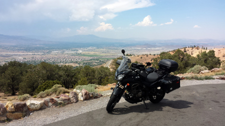
Jim and Laura live between Carson City and Minden. I arrived at
their house mid-afternoon. It was hot so their air conditioning
provided welcome comfort (as did that cold beer - thanks). |
Thursday I did not do any riding. Jim and I did a bit of desert
exploring. We also did some bike maintenance that day.
I had replaced the stock mirrors with Doubletake
Mirrors. I
really like them as they are infinitely adjustable and give great rear
view sight on both sides of the bike. These use a "ram mount" ball style
mount. This works great on a smooth road and up to about 65 MPH. But at
high speed or on a rough road the mirrors would slowly move back which of
course would make the view incorrect. The mounts have a metal "clamshell"
that clamps around a round plastic ball - a standard RAM mount. The
problem was that with really strong headwind due to high speed or if a lot
of vibration the mirrors would move. We took a center punch and made a
grid of 9 small indents in each half of the inside of this curved metal
clamp. I also took some very fine sand paper and lightly sanded the
plastic ball to remove the slick surface. This did the trick and the
mirrors worked perfectly for the remainder of the trip no matter what the
speed or how rough the road.
The other bit of maintenance that was needed involved my auxiliary
lights. I mounted some LED
lights down on the front forks utilizing a fender mount. The lights
came with a mounting kit that was a bag of parts designed to fit a number
of bikes. My fenders are a fiberglass material and had used a hex screw
with a very large diameter head to spread the clamping pressure over a
large area. The post used to mount the lights was a smaller diameter and
allowed very slight vibrations of the light to slowly wear away fender
material. I noticed this as when riding through Reno I could hear noise
from my front fender moving a bit when I would cross bumps at low speed.
Jim and I did some shopping at a hardware store and were able to change
the mounting method to get a large washer holding the fender in place.
This seems to have solved the problem.
|
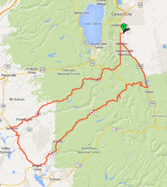
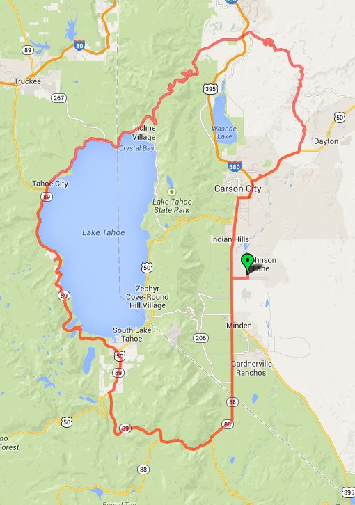
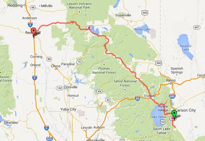
Jim
recommend this route taking me west on Highway 88 through the
Eldorado National Forest and then returning east on Highway 4 through
the Stanislaus National Forest. Click the map to the left for a
larger image.
Both roads have pretty good elevation so the temperature was not too
bad. I got fuel just north of Jackson on highway 49 and then headed
south to make my return trip. That area was warm but traffic was
light and the day very nice.
Highway 4 was quite amazing. Trailers are not allowed and there is a
limit to vehicle length. |
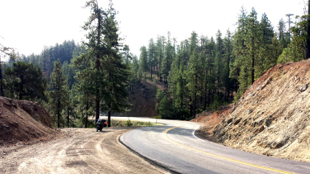
This stretch of Highway 4 turned out to be great fun, definitely the most
exciting road of the trip. The road has mile after mile of very tight
turns and some very steep drops as well. The V-Strom is a nimble bike and
handled the twists of this road like a champ. I had never been on any road
like this (not with a car or bike) and after completing the ride felt that
I could now handle any road I might encounter.

|
I
was creating a track using my phone and the Google map "my tracks"
feature. When looking at the map I saw this interesting "glitch" to
the west of Topaz on highway 4. |
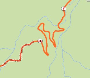
|
Expanding
the map revealed one of the more steep and twisty spots in the road.
When I saw the expanded view I recalled exactly where this was -
some of the steepest drops on the road with very sharp turns waiting
at the bottom. This was definitely a road to run west to east for
maximum excitement. |
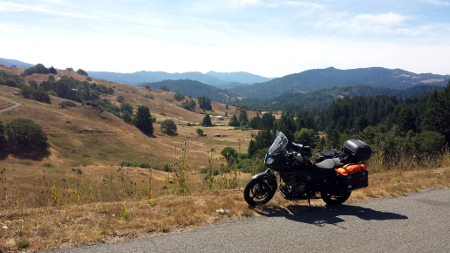
Some photos from Friday's ride. Click on photos to open a larger image.
|
This is Sorensen's
resort.
It can be found on Highway 88 not too far from South Lake Tahoe. Jim
recommended this as a breakfast stop. What a great idea. The
breakfast was great and the setting was beautiful. You can eat
indoors or out. |
|
This is an all winter resort with activities for all seasons. I
hope to return and spend a couple days relaxing here. |
|
This
is a stretch of Highway 88. There was very little traffic and great
riding weather. |
|
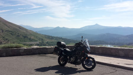
A
stop at Red Lake Vista Point on Highway 88. |
 |
Another view along Highway 88. |
|
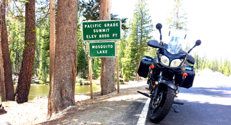
I would think that the name "Mosquito Lake"
would serve as notice that this is not a great place to be but there
is a camp ground here and people at the lake. This is on Highway 4. |
|
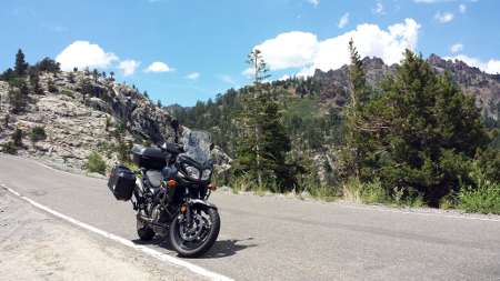
Highway 4 heading down toward Topaz Lake. A
clear road and no traffic, lots of curves. A bit after this the
afternoon clouds began to gather and I did ride through just a few
drops of rain. Fortunately that did not last long and I was back and
Jim and Laura's place before the typical late afternoon showers
started. |
|
After the very technical ride of Friday I
thought I would have an "easy" day of a ride around Lake Tahoe, then
through Virginia City and back to home base. While the distance made
this the shortest day of the trip the heat and slow traffic around
the lake did not make the day seem easy.
I headed south on Highway 88 initially retracing some of the
previous day's route. Jim recommended breakfast at the Getaway Cafe on highway 50
leading up to Lake Tahoe. The weather was nice and I was able to
enjoy my breakfast at an outdoor table. This is a popular place and
I was fortunate to not have a long wait.
After breakfast I continued north connecting with Highway 89 on the
west side of the lake. It was very hot and the Saturday summer
traffic around the lake really slow. There are lots of small towns
around the lake and traffic through them is slow so I was very hot
by the time I reached Incline Village on the north side of the lake.
There I was able to get on the Mount Rose Highway and enjoy some
fantastic twists and turns as the road descends down to the valley
floor (if you can call 5000 foot elevation a "floor").
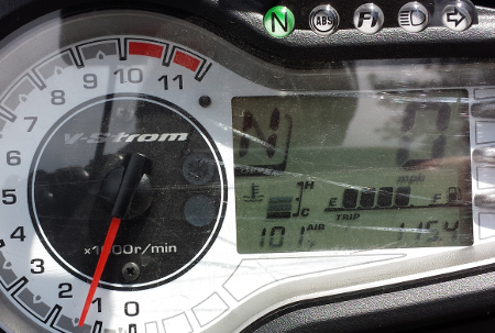
I crossed Highway 395 and then began the climb up Geiger Grade Road
(Highway 341). Despite gaining elevation the temperature was rising
as the day progressed and I saw the air temperature gauge on the
bike cross past 100 degrees. The high I saw this day was 105 degrees
(that's 40 C for those of you not in the USA).
On the descent of Geiger Grade Road I passed through Virginia City,
Nevada. The town was full, I did not see a single empty parking spot
on the main street that runs through the town. I did not intend to
stop as by now I was hot and ready to finish up my day. I had to
pack up everything and start my journey back to home the next
morning. |
|
The bike air temperature gauge showing 101
degrees as I climbed Geiger Grade Road. |
|
A lookout point on Geiger Grade Road. |
|
I started out Sunday with a short ride
south into Minden so that I could join Jim and Don for breakfast. I
had heard Jim speak of Don and enjoyed meeting him. I backed track
north on 395 and then headed west on Highway 50 climbing up to the
Tahoe rim. I rode around the north end of Lake Tahoe back to Incline
Village and at Kings Beach got on Highway 267 heading northwest and
leaving Lake Tahoe. Fortunately being early Sunday morning the
traffic at the lake was not yet too heavy.
The road turns into Highway 89 once you cross over Interstate 80. I
went through a couple very brief rain showers. Just a few minutes of
rain and with the warm temperature the moisture evaporated quickly.
The road eventually merges with Highway 70 following streams for
much of the ride.
Highway 70 spits off heading west with 89 heading north to Lake
Almanor. The town of Chester by the lake is the only spot for fuel
for about 60 miles more so I stopped there to get fuel and also
enjoyed a milk shake. After leaving Chester Highway 36 leads west to
Red Bluff. |

|
This was the longest ride of the trip - 343
miles. After having some great rides and also some really slow
traffic around Lake Tahoe I did not feel like dealing with the slow
traffic up Highway 101 on the Oregon coast so I opted to take I-5
north. Even though this day started on I-5 I wanted to ride Highway
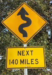
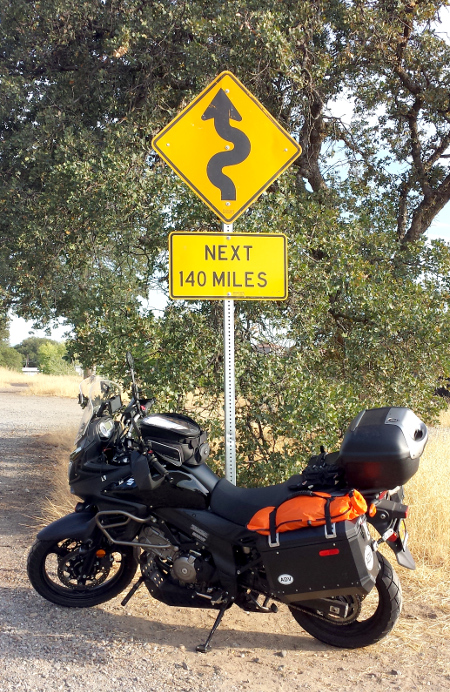
36 from Red Bluff to the California coast - 140 miles of curves!
Highway 36 heads east out of Red Bluff with the well known (to
motorcyclists at least) sign showing 140 miles of curves. I made a
stop to take a picture of my bike with that sign. And then it was
west on Highway 36 enjoying all those curves. There is not much
traffic on this road and what few cars I encountered immediately
pulled over for me when I came up behind them. I was not driving
fast by any means, but the cars on the road seemed to understand
that a bike could easily proceed faster than them. So a big thanks
to those courteous drivers that let me past. For an expanded look at
the map showing a section of the highway 36 curves click here.
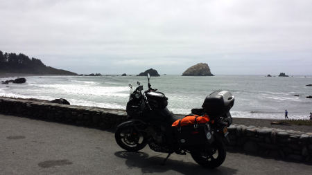
Highway 36 intersects with Highway 101 near Fortuna. From there I
headed north to Crescent City and took Highway 199 back through the
mountains to Grants Pass. |
Some photos from Monday's ride. Click on photos to open a larger image.
|
Just outside Red Bluff as Highway 36 starts
the journey west. I'm sure every motorcyclist feels compelled to
stop and get a photo. |
|
When planning the trip I considered a
return route taking me up the Oregon coast. After experiencing the
traffic around Lake Tahoe I felt as if I had encountered enough slow
traffic for a while and did not think all the congestion one finds in
the small Oregon coast towns was going to be much fun. I do a fair
amount of riding on the coast on day trips and have this area
available most any time. That led to a route change using Interstate
5 as a return route.
I spent Monday night in Grants Pass after 343 miles of riding, much
of that on twisty roads. I was quite tired by the time I made the
stop. The next morning I saw signs of recent rain as I headed north
and the sky was overcast. A call to my wife indicated rain in the
Portland area. The sky cleared as I headed north and I arrived in
Portland to find clear skies. |
Summary
This was a great trip! The weather was good - morning riding really
fantastic though a bit hot later in the day on most days. Jim tells me
that there was very heavy rain later the day I left Nevada so I had good
timing on that exit. And on my last morning in Grants Pass I could see
that it had rained during the night as I was riding north so again my
timing was good to avoid that rain. There are some wonderful motorcycle
roads in southern Oregon, northern Nevada, and northern California. I feel
fortunate to have had so many days available to explore those roads.
The bike was a 2012 Suzuki V-Strom 650. The bike performed flawlessly.
This is the adventure model with factory side cases and factory top case.
I strapped a small water proof bag to one side case to provide a little
more room to pack clothes. I had some tools and emergency gear with me as
well as the rain liners for my riding clothes. I never needed any of that
but it was good to have. I also carried a Samsung Chromebook tablet
computer as well as a Nexus 10 tablet. I have a USB power outlet wired
into the bike and used that power source to run a Garmin Nuvi GPS and also
keep my phone powered. I had my Samsung S4 phone in the tank bag on the
trip and ran the Google mapping "my tracks" application to capture track
logs for each day. The GPS is a reasonably inexpensive model I picked up
at Costco and designed for automobile use. As such it lacks some of the
features found on a GPS designed for motorcycle use but the cost is not a
lot over $100, far more reasonable than a unit designed for motorcycles.
The GPS was a huge help on the trip. I did sometimes make notes about
routes and placed those under the plastic window of the tank bag but for
the most part would set a waypoint on the GPS and use that if I had any
questions about the route. The biggest flaw of the GPS is the power
connection - a micro USB cable not really designed for the vibration of a
motorcycle. And Garmin decided that a standard USB cable should switch the
GPS into a "data transfer" mode such that it cannot be used for
navigation. It is necessary to purchase a special cable with a resistor
across two pins if you wish to power from USB while navigating. This is
the biggest flaw with the unit and a stupid design decision. There is no
reason why an option entered through the touch screen could not switch the
unit to the data transfer mode. On the last day of the ride the GPS seemed
to lose power and sometimes reset as if the power connection was
intermittent. I believe either the cable or connector has failed. Some
debugging is needed.
The V-Strom did fine on the highway and easily carried all my gear. The
bike corners well and really seemed perfect when it came to all the twisty
roads I found. The bike has a 5.3 gallon fuel capacity and gets about 50
MPG so can achieve a good distance between fuel stops. I would fill up at
the end of each day so I could start the next days ride with a full tank.
I used fuel stops as a good stretch break and unless on the interstate
with plentiful gas stations never let the fuel get too low.
My riding gear consists of Motoport
stretch Kevlar pants and a Motoport stretch Kevlar jacket. Both with full
armor inserts. The combined weigh of those is fairly high but they are
quite comfortable and the weight is not felt once on the bike. The company
also makes a mesh Kevlar line of gear which would be better suited to the
very hot weather I encountered on the trip. My jacket does have good
ventilation with a back zipper across the shoulders and zippers on the
inside of each elbow. I wore shorts under the pants and a very light short
sleeve shirt under the jacket and found that this worked out quite well. I
was also wearing gloves (again from Motoport), motorcycle boots and a full
face helmet. Even with all the gear I was wearing most of the riding was
comfortable. Not knowing how the weather would be for the duration of the
trip I took along my rain inserts for the riding suit as well as the
quilted vest insert. That added a bit of bulk to the gear I had to carry.
This turned out to not be necessary though it nearly was near the end of
the ride.


